# Driving from Calais to La Rochelle: Route and Tips
Planning a road trip from Calais to La Rochelle represents one of France’s most rewarding cross-country drives, stretching approximately 690 kilometres through diverse landscapes and historic regions. This journey takes you from the northern Channel ports deep into the sun-drenched Atlantic coast, passing through the heart of France’s remarkable countryside. Whether you’re heading to the charming coastal city of La Rochelle for a family holiday, exploring the nearby Île de Ré, or continuing further south towards the Charente-Maritime region, understanding your route options and preparation requirements will transform your journey from a simple transit into an enjoyable part of your French adventure.
The drive typically requires between six and nine hours depending on your chosen route, traffic conditions, and the number of stops you make along the way. With proper planning, vehicle preparation, and strategic rest breaks, this continental crossing becomes a manageable and even pleasant experience. The French motorway network offers excellent facilities, whilst alternative routes through smaller towns provide cultural richness and scenic diversity that many travellers find genuinely rewarding.
Optimal route planning: A16 autoroute and A10 corridor via paris
The most direct and commonly recommended route from Calais to La Rochelle follows the French autoroute system, primarily utilising the A16, A1, and A10 motorways. This combination offers the fastest journey time, typically around six to seven hours in normal traffic conditions, and provides excellent road surfaces, comprehensive signage, and regular service facilities. The route takes you southward from Calais along the Channel coast before turning inland towards Paris, then continuing southwest along the A10 towards Poitiers and the Atlantic coast.
Starting from the Eurotunnel terminal or ferry port at Calais, you’ll join the A16 heading south towards Boulogne-sur-Mer and Abbeville. This initial section sets the tone for your journey with well-maintained dual carriageway driving through the Hauts-de-France region. The landscape here features gently rolling countryside, occasional glimpses of coastal chalk cliffs, and the characteristic agricultural plains of northern France. This opening stretch allows you to settle into continental driving patterns and adjust to navigating French road systems.
Navigating the A16 péage from calais to abbeville: toll costs and service stations
The section between Calais and Boulogne-sur-Mer remains toll-free, offering approximately 45 kilometres of uninterrupted motorway driving. However, from Boulogne onwards, you’ll encounter your first péage (toll station) as you continue towards Abbeville. The toll between Boulogne and Abbeville typically costs around €7-9 for a standard car, though prices fluctuate based on vehicle classification and periodic adjustments. Many British drivers initially find the toll system slightly daunting, but modern payment technology has simplified the process considerably.
Most toll booths accept major credit and debit cards, including contactless payments, making transactions swift and straightforward. Your UK-issued Barclaycard, Visa, or Mastercard will work perfectly at these automated barriers. Some travellers worry about card compatibility, but recent infrastructure improvements mean that payment difficulties have become increasingly rare. If you prefer cash transactions, euros are naturally accepted at manned booths, though carrying exact change isn’t necessary as change is provided.
Service stations along the A16 appear at regular intervals, typically every 40-60 kilometres, offering fuel, refreshments, toilet facilities, and often small shops stocking travel essentials. Notable service areas include those at Boulogne and near Abbeville, where you’ll find comprehensive facilities including restaurants, children’s play areas, and picnic spaces. These represent ideal stopping points if you’re travelling with young children who need opportunities to stretch their legs and burn off energy during the journey.
A26 junction strategy: bypassing paris via reims or direct A1 approach
Upon reaching Abbeville, you face a strategic decision regarding your onward route. The most common approach involves continuing on the A28 towards Rouen, then joining the A13 and eventually the A10
that skirts the western side of Paris. However, many drivers prefer to use the A26 and A1 corridors to either bypass or approach the capital more directly. This is where careful junction planning can significantly influence both your overall journey time and stress levels.
Taking the A26 south from the A16 near Saint-Quentin allows you to route via Reims and Orléans, avoiding the most congested sections of the Paris ring roads. Alternatively, continuing towards the A1 offers a more direct line into the capital’s motorway network but increases your exposure to heavy traffic, especially at peak times. Your choice here should balance driving confidence, familiarity with French motorways, and your tolerance for urban congestion versus longer yet potentially calmer alternatives.
For many travellers driving from Calais to La Rochelle in one day, minimising complexity is key. In such cases, following the clearly signed A1 towards Paris and then picking up the A10 remains the simplest option, especially when supported by up-to-date sat nav or mapping apps. If you’re splitting the journey over two days, the A26–Reims route can become more attractive, giving you additional overnight stop options in Champagne country or around Orléans.
A26 junction strategy: bypassing paris via reims or direct A1 approach
So, should you opt for the A26 via Reims or head straight for the A1 towards Paris? The A26–A19–A10 “eastern arc” bypass is often preferred by drivers who dislike ring-road driving. From the A16 you join the A26 near Arras, then continue towards Reims before picking up the A19 and A10 south of Paris. This route adds some distance compared to the direct A1 approach, but you trade kilometres for calmer, more predictable traffic flows.
The direct A1 approach brings you towards Paris Charles de Gaulle airport and then onto the A3 or A104, feeding into the A86 and the périphérique. While this corridor is well signposted, it can suffer heavy congestion during weekday rush hours and holiday crossovers. If you must take this route, plan to reach the Paris area outside peak times—ideally mid-morning or early afternoon on weekdays, or before 10:00 on Saturdays in peak season. Night-time transit remains an option for confident drivers comfortable with reduced visibility and heightened fatigue risk.
Cost is another factor. The péages on the A26 and associated bypass motorways are similar in price to the more direct approach, so the decision is rarely about saving money. Instead, you’re optimising your mental energy. Think of it as choosing between a shorter but busier queue and a slightly longer but steadily moving line. If you’re driving with children or after a long Eurotunnel crossing, that steadier line often feels far more manageable.
Périphérique vs A86 ring road: traffic pattern analysis for transit efficiency
Once you commit to passing near Paris, you’ll face another common dilemma: use the inner Boulevard Périphérique or opt for the outer A86 ring road. The Boulevard Périphérique hugs the city limits and is technically shorter, but it functions more like an urban expressway than a true motorway. Multiple junctions, variable speed limits, and dense weaving traffic can prove stressful for those unfamiliar with French city driving.
The A86, by contrast, forms a wider arc around Paris and is often the better option for through-traffic heading towards the A10. Although the total distance is slightly greater, traffic tends to be more fluid, signage is clearer, and you’re less likely to be caught in stop-start conditions typical of the périphérique at rush hour. If your navigation system offers a “fastest route” and a “less traffic” option, comparing both in real time can be helpful, especially in peak holiday periods.
When analysing traffic patterns, consider day of week and season. Summer Saturdays, French bank holidays, and the traditional “chassé-croisé” weekends (when holidaymakers swap over en masse) can turn both the périphérique and A86 into bottlenecks. In those cases, timing is everything. Leaving Calais very early or very late can mean you transit the Paris area in relatively light traffic, turning a potentially stressful section into just another stretch of motorway on your Calais to La Rochelle drive.
For many drivers, the most efficient strategy is to follow the A1 towards Paris, then take the A3 or A104 to the A86, and finally join the A10 southbound. This approach keeps you on high-standard roads with clear, consistent signage labelled towards Bordeaux and Nantes, your key markers for eventually reaching La Rochelle via the A10 corridor.
A10 L’Aquitaine southbound: distance markers and strategic rest areas to la rochelle
Once you join the A10—often signed as L'Aquitaine—your route to La Rochelle becomes straightforward. The A10 runs southwest from the Paris region past Orléans, Tours, and Poitiers, before you branch off towards Niort and La Rochelle. From the outskirts of Paris to the La Rochelle junctions, you’ll cover roughly 450 kilometres, with kilometre markers and frequent distance boards keeping you informed of remaining distance to key cities.
Major service areas (aires) are spaced at comfortable intervals, usually every 30–50 kilometres, alternating between simple rest areas with toilets and picnic tables, and full-service stations with fuel, restaurants, and shops. Notable full-service aires include those near Orléans, the popular Aire de Tours la Longue Vue, and several large complexes between Tours and Poitiers that are particularly family-friendly. These are prime places to schedule longer breaks, especially if you’re managing driver fatigue on a long Calais to La Rochelle driving day.
As you progress south, signage for Bordeaux becomes more prominent, but keep an eye out for Niort, La Rochelle, and Île de Ré on the boards. Typically, you’ll leave the A10 around Niort to pick up the A83 and then the N11 or D137 towards La Rochelle. Planning one or two 20–30 minute breaks along the A10, plus a longer meal stop, tends to strike a good balance between progress and comfort. Remember: treating your journey like a marathon rather than a sprint makes the arrival in La Rochelle feel far more relaxed.
Alternative inland routes: n-roads and scenic departmental options
Not everyone wants to spend the entire day on motorways. If you’re happy to add an hour or two to your total travel time, France’s N-roads (routes nationales) and D-roads (routes départementales) offer a more scenic, often less expensive way to drive from Calais to La Rochelle. These roads frequently follow former national routes, with good surfaces, gentler traffic, and access to authentic small towns and villages where you can stop for a leisurely lunch.
One common strategy is to mix autoroutes and N-roads. For example, you might use the A16 and A28 to get clear of northern France quickly, then drop onto departmental roads south of Le Mans or around Saumur and Niort. This hybrid approach keeps your Calais to La Rochelle drive time reasonable while giving you glimpses of the Loire Valley, rural Poitou-Charentes, or lesser-known market towns. It’s a particularly appealing option if you’ve planned an overnight stop instead of driving the entire distance in a single day.
Of course, slower roads demand more concentration. You’ll encounter roundabouts, local speed limits, and the occasional agricultural vehicle. Think of it as trading cruise-control motorway monotony for a more varied, engaging driving experience. If your idea of a French road trip includes tree-lined avenues and medieval church spires rather than service-station forecourts, these alternative inland routes are well worth considering.
D939 through Poitou-Charentes: mileage comparison and rural road conditions
One of the most pleasant alternatives in the final third of the journey is the D939, which crosses parts of the Poitou-Charentes region. Formerly a national route in many sections, this road provides a practical compromise between speed and scenery, linking towns such as Saumur, Thouars, Parthenay, and Niort. Compared with sticking solely to the A10 and A83, you may add 30–60 minutes to your drive, depending on traffic and stops, but you’ll save on tolls and gain more varied landscapes.
Road conditions on the D939 are generally good, with wide single carriageways, frequent overtaking sections, and clear signage. Speed limits usually sit at 80–90 km/h outside towns, dropping to 50 km/h as you pass through villages. If you’re used to UK A-roads, the driving environment will feel familiar, albeit with fewer roundabouts and typically less congestion. The key is to remain alert to changing limits and local traffic, especially around school times and market days.
From a mileage perspective, incorporating the D939 between Saumur and Niort might only add 20–40 kilometres overall compared with a pure autoroute plan. Yet that slight increase often delivers a better sense of place. You’ll see vineyards, sunflower fields, and traditional farmsteads—scenes that motorway embankments tend to hide. For many road-trippers, this is precisely the sort of experience that transforms driving from Calais to La Rochelle into a genuine holiday highlight.
Niort and surgères bypass strategies: avoiding town centre congestion
As you approach the Atlantic coast, managing traffic around medium-sized towns like Niort and Surgères becomes increasingly important. While both towns are perfectly pleasant, threading through their centres can cost precious time, especially during commuter hours or market days. Fortunately, recent improvements in bypass routes and ring roads make it easier than ever to skirt congestion while still benefiting from nearby services.
Niort, situated on the main axis between Poitiers and La Rochelle, is ringed by a series of well-signposted bypasses that connect the A10, A83, and N11. If your goal is efficiency, follow signs for La Rochelle and avoid leaving these peripheral routes unless you need fuel or food. Many sat nav systems will try to cut through suburban streets to save a kilometre or two, so it’s worth double-checking your route zoomed out to ensure you’re sticking to the main bypass corridors.
Further west, Surgères serves as a junction point for traffic heading towards Rochefort or the coastal islands. Here too, a small ring of distributor roads lets you avoid the historic town centre’s narrow streets and frequent pedestrian zones. If you’re travelling in high season or towing a caravan, staying on these wider bypasses can significantly reduce stress. When in doubt, following signage for La Rochelle, Rochefort, or Saintes will usually keep you on the most appropriate through-routes.
RN11 coastal diversion via rochefort: distance trade-offs and atlantic views
For drivers looking to add a touch of Atlantic atmosphere before arriving in La Rochelle, a diversion via the RN11 and Rochefort can be very appealing. Instead of heading directly to La Rochelle along the D137, you continue towards Rochefort-sur-Mer, a historic naval town on the Charente estuary, and then loop north along the coast. This coastal diversion can add 30–50 kilometres, but rewards you with estuary views, salt marshes, and an early sense of the region’s maritime character.
The RN11 and associated departmental roads are mostly flat and straightforward, with a mix of dual and single carriageway sections. Traffic levels rise in July and August, particularly near popular beaches and island access points, but outside peak weekends the flow remains comfortable. If you’re planning a late-afternoon arrival and want to break the final leg with a seaside stop, Rochefort or nearby Fouras-les-Bains make excellent options. You can stretch your legs along the waterfront before completing the short hop up to La Rochelle.
Is the extra distance worth it compared to a direct autoroute-to-city approach? That depends on your priorities. If you’re racing to catch a rental check-in window, stick to the main D137 and N11 corridor. But if you have some flexibility and you’re drawn to the idea of seeing the Atlantic before you even reach La Rochelle, this RN11 diversion provides exactly that—a preview of the coastal scenery that defines Charente-Maritime.
Vehicle preparation and cross-channel documentation requirements
Successful route planning is only half the equation when driving from Calais to La Rochelle; proper vehicle preparation and documentation are just as important. France maintains clear legal requirements for what you must carry in your vehicle, and post-Brexit regulations have added several details that UK drivers in particular need to consider. Being well prepared not only keeps you on the right side of the law but also significantly reduces stress if you’re stopped for a routine check.
Before setting off, check that your vehicle is in good mechanical condition. A long motorway run will quickly highlight any underlying issues with tyres, brakes, or cooling systems. A simple pre-trip inspection—tyre pressures, oil level, coolant, and screenwash—takes minutes yet can prevent breakdowns on busy autoroutes. Remember that breakdown cover with European assistance is strongly recommended; without it, recovery and repair costs can escalate quickly if something goes wrong halfway between Calais and La Rochelle.
Beyond mechanical checks, assemble a small folder containing your essential documents. At a minimum, this should include your driving licence, V5C registration document, insurance certificate showing Europe-wide cover, and if applicable, your hire car agreement. Keeping digital copies stored securely on your phone or cloud service provides a useful backup. While you may never be asked to show these, having them easily accessible can turn a potentially awkward roadside conversation into a brief formality.
GB sticker regulations and headlight beam deflectors for right-hand drive vehicles
One of the most frequently asked questions from UK drivers concerns country identifiers on the rear of the vehicle. The traditional “GB” sticker has now been replaced by the “UK” identifier. If your car’s number plate already includes the UK flag and marking, you do not need an additional sticker within the EU. However, if your plate only shows the old GB badge or has no country identifier, you must affix a separate UK sticker to the rear of the vehicle before you drive off the ferry or Eurotunnel.
Headlight beam deflectors are another essential item for right-hand drive vehicles. Because UK headlights are angled slightly left to avoid dazzling oncoming traffic at home, they can create glare for French drivers when you switch to driving on the right. Simple adhesive deflectors, widely available at ports, service stations, and online, redirect the beam pattern. Fitting them is usually a quick process, guided by diagrams specific to your headlight type. Some modern cars allow electronic adjustment via the on-board computer; in that case, consult your manual and ensure the “continental” setting is activated before night driving.
Ignoring these requirements can lead to on-the-spot fines if you’re stopped by French police, and more importantly, compromises safety. Think of beam deflectors as a pair of sunglasses for your car—small, inexpensive, but crucial when the light hits at the wrong angle. Checking and fitting them before you roll off in Calais ensures your drive to La Rochelle remains both legal and considerate to other road users.
Breathalyser kits, warning triangles, and high-visibility vest compliance
French motoring law also specifies certain safety equipment that must be carried in your vehicle. While enforcement has softened over time for some items, it remains good practice—and in many cases still a legal requirement—to have them on board. A reflective high-visibility vest for each occupant should be stored inside the passenger compartment, not in the boot, so that you can put it on before stepping out onto the carriageway in an emergency. At least one warning triangle is also mandatory and should be deployed behind the vehicle if you break down on a non-motorway road.
The long-debated requirement for drivers to carry a personal breathalyser kit (éthylotest) has been effectively suspended, with no active fines for non-compliance in recent years. However, inexpensive kits are still widely available at French supermarkets and service stations, and some travellers like the reassurance of having one to self-test after a meal involving wine. When in doubt, prioritise the essentials: vests, triangle, spare bulbs where applicable, and a first-aid kit, even if the latter is not strictly required.
Also remember that you must carry your original vehicle registration (V5C) and proof of insurance, and that UK drivers should now have a valid passport stamped on entry and exit. If you’re using a hire car, the rental agreement will typically confirm permission to drive in France; keep it handy in case authorities request proof. With these basics covered, you can focus on enjoying the drive rather than worrying about unexpected equipment checks along the A10.
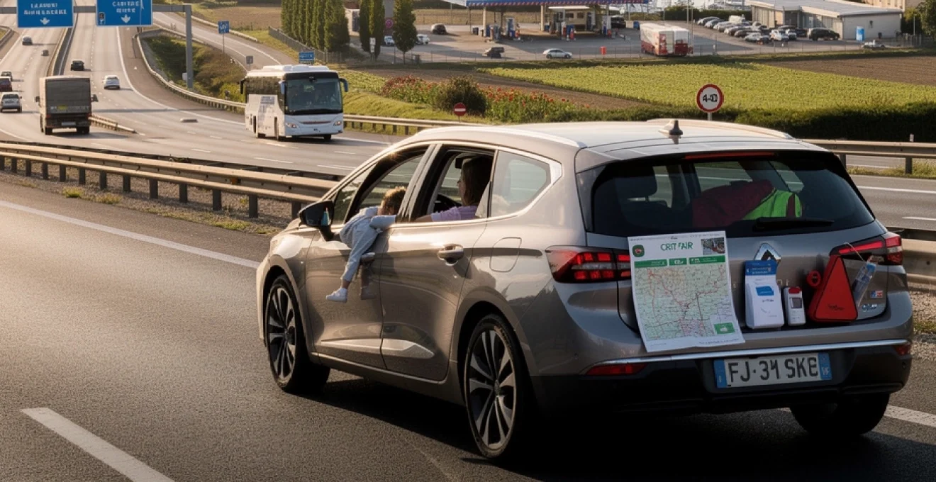
Crit’air vignette classification for low emission zones in french urban areas
As more French cities introduce low-emission zones (Zones à Faibles Émissions, or ZFE), the Crit'Air vignette has become an important consideration for cross-country drivers. This coloured sticker, displayed on your windscreen, categorises your vehicle based on its emissions standard. Paris, Lyon, Grenoble, and several other major cities already require Crit’Air stickers for certain areas and times, with more urban centres joining the scheme each year.
If your Calais to La Rochelle route involves driving into or near Paris, Rouen, or any other designated low-emission city, it’s wise to check current requirements on the official government site and order your vignette at least six weeks before departure. The application process is straightforward and inexpensive, but you must complete it online using your vehicle registration details. Beware of unofficial third-party sites charging inflated fees; stick to the official French government portal.
Many drivers simply transit the outskirts of cities such as Rouen or Paris on the autoroutes, which typically remain accessible without Crit’Air restrictions for through traffic. However, regulations can evolve, and temporary pollution peaks occasionally trigger stricter rules. Think of the Crit’Air sticker as a small, proactive investment in flexibility: even if you don’t plan to enter a city centre, having it in place gives you more options if you need to divert or make an unplanned overnight stop near an urban area.
Fuel strategy and service station distribution along A10 corridor
Fuel planning on the Calais to La Rochelle route is simpler than many first-time drivers expect. The A16, A1, and A10 corridors are well supplied with service stations, and you’re rarely more than 50–70 kilometres from a filling opportunity. Nevertheless, a sensible fuel strategy can save money and reduce anxiety, especially if you’re unfamiliar with French fuel terminology or driving a fully loaded vehicle in summer heat.
Motorway service areas (aires de service) are the most convenient refuelling points, operating 24/7 and accepting major cards. However, prices here are typically higher—sometimes by €0.10–0.20 per litre—than at supermarkets such as Leclerc, Intermarché, or Carrefour located just off the main roads. If you’re travelling on a budget and have time to spare, planning one stop at a supermarket fuel station near Tours, Poitiers, or Niort can result in noticeable savings over a full tank.
Diesel is labelled gazole or diesel, while standard unleaded petrol is usually marked as SP95 or SP98, with SP95-E10 indicating a higher ethanol blend that not all older vehicles can use. Check your handbook if you’re unsure which grades your car accepts. As a rule of thumb, avoid letting the tank fall below a quarter on long stretches of autoroute; this buffer protects you against unexpected closures or diversions, and gives you more choice about where to stop rather than being forced into the nearest, and often priciest, option.
When it comes to payment, chip-and-PIN and contactless cards from major UK banks work at most attended stations. Unmanned 24-hour pumps at supermarkets can be more variable, sometimes preferring French or EU-issued cards, though compatibility has improved in recent years. If you’re concerned, keeping a modest float of cash euros—say €50–€100—provides a useful backup. With a little planning, refuelling simply becomes another smooth part of your journey down the A10 towards La Rochelle.
Accommodation waypoints: tours, poitiers, and niort stopover options
Not everyone wants to tackle the entire Calais to La Rochelle distance in one day. Splitting the journey with an overnight stop can turn a long haul into two relaxed drives, and opens up opportunities to sample some of central France’s most attractive mid-sized cities. Three particularly convenient waypoints along or near the A10 corridor are Tours, Poitiers, and Niort, each offering a good mix of accommodation, dining, and family-friendly facilities.
Tours, roughly halfway between Paris and La Rochelle, makes an excellent first-night stop if you’re catching a mid-morning Eurotunnel or ferry. The city sits on the Loire river and offers everything from budget chain hotels near the autoroute to charming old-town guesthouses. Many properties provide secure parking—important if your car is loaded with holiday gear. After parking up, you can stretch your legs in the historic centre, grab dinner on Place Plumereau, and enjoy the feeling that your holiday has truly begun rather than merely pausing at a motorway hotel.
Further south, Poitiers lies a comfortable drive from both Calais and La Rochelle, making it a flexible stop on either the outward or return leg. Accommodation options range from simple roadside hotels near the A10 junctions to more characterful stays within the medieval city core. Families often appreciate the proximity to Futuroscope, a popular theme park just north of Poitiers, although this can increase demand in peak holiday periods. Booking ahead is advisable in August and on French public holiday weekends.
Niort, closer again to La Rochelle, is ideal if you prefer to do most of the driving on day one and enjoy a shorter final hop to the coast. Hotels and chambres d’hôtes are scattered around the town and its ring road, with several major chains clustered near the A10/A83 junctions for easy access. If you arrive in time, a brief stroll along the Sèvre Niortaise river or through the old quarter offers a pleasant change of pace from the motorway. Whichever waypoint you choose, aim to time your arrival before nightfall where possible; navigating unfamiliar streets and hotel car parks is always easier in daylight, particularly with children in tow.
Weather considerations and seasonal traffic patterns on Calais-La rochelle axis
Finally, no discussion of driving from Calais to La Rochelle would be complete without considering weather and seasonal traffic. France’s climate varies significantly along this north–south axis, and conditions on the same day can differ markedly between the windswept Channel coast and the warmer Atlantic fringe around La Rochelle. In summer, expect higher temperatures and stronger sunlight as you head south; in winter, the northern stretches can be rainier and, on rare occasions, affected by snow or ice.
Peak holiday periods—especially late July and early August—see traffic volumes surge on the A10 and major cross-country routes. The famous “black Saturdays” (samedis noirs) are when much of France takes to the road at once, leading to congestion and extended travel times. If you have flexibility, avoiding these weekends can make your Calais to La Rochelle journey markedly smoother. Travelling midweek outside of school holidays almost always means lighter traffic, easier service-station parking, and less pressure around the Paris area.
Weather can also amplify or mitigate traffic issues. Prolonged heatwaves may cause more breakdowns, particularly among older or heavily loaded vehicles, which in turn create localised slowdowns on busy stretches. Heavy rain around Paris and Tours can reduce visibility and increase stopping distances, demanding extra caution. Before you set off, checking a reliable forecast for the entire route—rather than just your departure and arrival points—helps you anticipate any challenging segments.
In shoulder seasons such as late spring and early autumn, you often enjoy the best of both worlds: manageable traffic and mild, pleasant driving conditions. This can be an ideal time to combine the efficiency of the A10 corridor with occasional forays onto scenic N-roads, making the Calais to La Rochelle drive not just a means to an end, but an integral, enjoyable part of your French coastal escape.